Ever used Google Earth and noticed that there’s some cloud in a shot of details aren’t as clear as they could be? Google are addressing this with new satellites and technology to stitch the best possible images together.
There are some truly stunning images of our planet available on the satellite images of Google Maps and by searching through their available images, they have gone from amazing to perfect without any distortion or obstruction as can be seen in the maps blog post. Google also discuss the use of Landsat 8 for capturing new images and updating the Satellite view of Maps which when you compare old:
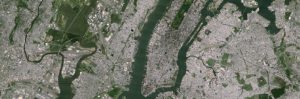
to new:
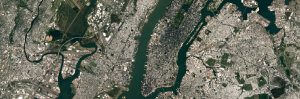
These are clearly the same shot, but chalk and cheese with regards to the resulting image clarity. I’m personally in awe of the beauty of our planet regularly and now we can all see much more of it clearly thanks to the commitment Google have to improving their products.
Where is the most stunning satellite image you’ve found on Maps?