Google IO is unfortunately becoming increasingly well known for showing off devices or features that never seem to make it out of Mountain View, looking at you Nexus Q and fence-removal tool in Google Photos! At IO 2018 Google showed of AR (augmented reality) navigation in Google Maps, and since then we hadn’t heard anything, however over the weekend it was announced that Google has continued to work on the feature and it will be out for user testing soon.
For those in the Local Guides community you may soon have reason to be excited, as regular contributors to the Local Guides program might get the chance to try out the new feature. As with all Google trials, well products and services in general, it’s unclear in which markets AR navigation will be tested.
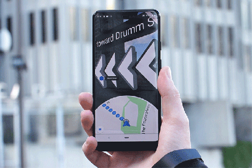
To use AR navigation there will be a new “Start AR” navigation button next to the current “Directions” button. After launching AR Navigation the entire display will be taken over with a feed from the camera with live directions overlayed and a game style “radar” style map at the bottom showing you the basic directions.
While navigating the user moves the device to follow the path and using a combination of Street View data, Local Guides data and AR Core the UI constantly updates using location and landmark to give you up-to-date walking directions. Walking is an important of this, this is NOT intended for driving, ever, at all, ok?
It’s early days yet for the feature, but with the Maps team being based in Australia we’re hopefully that either Australian Local Guides or trusted testers may be given the opportunity walk the new feature through it’s places. If you want to watch the original announcement from Google IO check it out below.