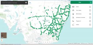
Roads and Maritime Service (RMS) have launched new webpage based on Google Maps which will show weary travellers the nearest rest area (and the facilities available). The service works well across both mobile and desktop, and uses geolocation to find rest areas in places that you mightn’t even know the name of. The service has offerings for both heavy vehicles (which often require larger areas) and regular motorists as well.
Transport for NSW has been on a campaign to reduce the number of fatalities on New South Wales roads from last year’s record of 201 road deaths to eventually zero. The RMS has said that diving tired is the second biggest killer on NSW roads after speeding, so it is important to remember to Stop, Revive, Survive.
This app will assist drivers (or more importantly their passengers) to find their nearest area to enable everyone to get out of the car and stretch their legs, use the facilities and freshen up a bit. Some rest areas even have parks or play equipment to keep the kids amused while drivers get a bit of fresh air.
Key features of the Rest Area map include:
-
- Works across all devices – mobile, tablet and desktop
- Plan your journey by entering your start and finish locations
- Geolocation – turn on location services to identify your location on the map; and
- Find rest areas based on the amenities available, including toilets, playgrounds, barbecue facilities and more.
Give it a try out for your next trip around NSW. The NSW Rest Areas map is available for your phone, tablet or desktop (it’s just a webpage) so it will work anywhere you’ve got internet access. Planning on travelling offline? Check it at home, make a note of where you might stop, and off you go!